Tel Code..: +235
Ethopian Airlines - THY
Viza..: Needs
Courses or boosters usually advised: Hepatitis A; Poliomyelitis; Tetanus; Typhoid; Yellow Fever.
Other vaccines to consider: Cholera; Diphtheria; Hepatitis B; Meningococcal Meningitis; Rabies.
Yellow fever vaccination certificate required for travellers over 1 year of age arriving from countries with risk of yellow fever transmission.
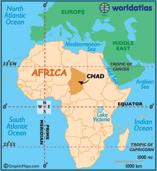
Name: Chad
President: Idriss Déby (1990)
Prime Minister: Djimrangar Dadnadji (2013)
Land area: 486,178 sq mi (1,259,201 sq km); total area: 495,755 sq mi (1,284,000 sq km)
Population (2012): 10,758,945 (growth rate: 2.0%); birth rate: 39.4/1000; infant mortality rate: 95.3/1000; life expectancy: 48.3.
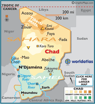
Capital and largest city (2009 est.): N'Djamena, 808,000
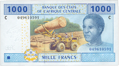
Monetary unit: CFA Franc
Read more: Chad:
Maps, History, Geography, Government, Culture, Facts, Guide & Travel/Holidays/Cities
| Infoplease.com http://www.infoplease.com/country/chad.html#ixzz38aEL5Uld
The ancient land called Chad was inhabited over one million years ago, at a time
when much of it was only water. In modern Chad, precious water is often
difficult to find, while famine and war seem everywhere.
Over the centuries it served as the stomping-ground of sorts for a litany of
cultures and kingdoms, beginning with the Saos in the 6th century BC. The Kanem
Empire became the longest-lasting in the region, gaining control in the first
millennium AD, and surviving until internal struggles aided in their collapse
towards the end of the 14th century.
 The French arrived
in 1891, and established complete control of the region. France governed
until Chad gained its independence in 1960, and Chadian Progressive Party (PPT)
leader, Francois Tombalbaye, we appointed the country's first president.
The French arrived
in 1891, and established complete control of the region. France governed
until Chad gained its independence in 1960, and Chadian Progressive Party (PPT)
leader, Francois Tombalbaye, we appointed the country's first president.
Decades of ethnic warfare followed, in addition to invasions from Libya,
its most powerful neighbor. A certain level of peace was restored in 1990, but
local power struggles continue, and the future of this unstable land is
uncertain.
On December 23, 2005, Chad declared a state of war against Sudan,
due to the Sudanese government's attempt at overthrowing Chadian president,
Idriss Deby. Failed attempts at overrunning the capital city of N'Djamena were
orchestrated by rebel forces in 2006 and 2008, both of which were blamed on Sudan.
A peace agreement was finally reached and signed on January 15, 2010, bringing
the five-year war to an end, and opening the borders between both countries.
Despite the peace treaty, Chad's foreseeable future remains unstable, and
organized gangs have begun to terrorize the region.
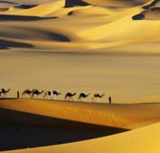 Much of the country is
positioned within the hot and dry (and mostly unproductive) Sahara Desert,
covering Chad with sand and barren scrub land. In the far south and southwest,
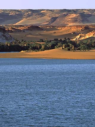
surrounding Lake Chad, conditions improve to support an abundance of wildlife,
as well as agricultural ventures.
Much of the country is
positioned within the hot and dry (and mostly unproductive) Sahara Desert,
covering Chad with sand and barren scrub land. In the far south and southwest,
surrounding Lake Chad, conditions improve to support an abundance of wildlife,
as well as agricultural ventures.
Chad's economy has recently benefited from a series of major oil field and
pipeline projects, while cattle, cotton and gum arabic have long been the
traditional economic mainstays.
Long term weaknesses include its landlocked position, oppressive poverty, the
shrinking of Lake Chad, and the ever increasing expansion of the Sahara Desert.
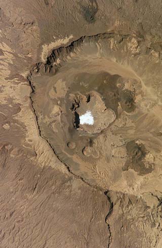
In
the northern reaches of the country, the Tibesti Mountains dominate the
landscape of the surrounding Sahara Desert.
The Sahel, on the southern edges of the ever-expanding Sahara Desert, is a
transition zone between the dry areas of the north and the tropical areas of the
south. It receives very little rain, and most of the vegetation is a savanna
growth of sparse grasses and shrubs.
The land rises into the Ennedi and Wadai plateaus along the eastern border with
Sudan, where elevations reach near 2000 ft (609 m).
In the south, the forested land is nourished by the Chari and Logone Rivers.
During the monsoon rains, Lake Chad often overflows, causing floods in the
lowland depression of the south.
The highest point of Chad is Emi Koussi, which rises 11,204 ft (3,415 m); the
lowest point of the country is the Djourab Depression at 524 ft (160 m).
Climate:
The Sahara Desert regions are hot and dry throughout the year, with little or no
rainfall. Temperatures are much cooler along the south-central Sahel. Rainfall
there averages near 15 inches annually. Drought, however, is commonplace.
In the southern regions, rainfall is much heavier, averaging near 30 inches
annually. The mean temperature in N'Djamena is 82°F (28°C)
Chad's landlocked position, poor transportation network, inadequate natural resources, and ongoing political turmoil have severely hampered economic development. The economy is based primarily on sedentary subsistence agriculture and nomadic pastoralism, employing 80% of the workforce but contributing only about 32% of the GDP. The best farming zone is in the south, where rainfall is sufficient for the cultivation of cotton and peanuts (the country's leading cash crops) for export and some subsistence crops, including sorghum, millet, rice, potatoes, and manioc. Cattle, sheep, goats, and camels are raised, and there is fishing in Lake Chad. During drought periods, Chad requires food aid to meet necessary levels.
Natron and uranium are the country's chief minerals, and petroleum is produced in the southern Doba basin, which is connected by pipeline with the Cameroonian port of Kribi. Industry is limited to food processing and the production of textiles and light consumer goods. Imports—largely machinery, transportation equipment, industrial goods, foodstuffs, and textiles—generally outweigh exports, mainly cotton, cattle, gum arabic, and oil. Chad's chief trading partners are the United States, France, Cameroon, and China.
Chad is governed under the constitution of 1996 as amended. The executive branch is headed by a president, who is elected by popular vote for a five-year term; there are no term limits. The prime minister is appointed by the president. Members of the 188-seat National Assembly are popularly elected for four-year terms. Administratively, Chad is divided into 22 regions.
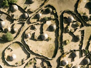
Land and People
The terrain in the south is wooded savanna; it becomes brush country near Lake Chad. The only important rivers are the Chari and the Logone, both of which flow into Lake Chad and are used for irrigation and seasonal navigation. Northern Chad is part of the Sahara Desert; areas of the mountainous Tibesti region there are 11,000 ft (3,353 m) high. The country has no railroads and few all-weather roads.
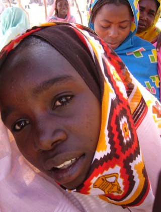
Chad comprises some 200 ethnicities, which fall into two distinct, and often hostile, population groupings. In the south, where the bulk of the population is concentrated, live sedentary agricultural peoples, including the Sara, Massa, Ngambaye, and Moundang; most are Christians, but some follow traditional religions. In the north are seminomadic and nomadic Muslim peoples, including Arabs, Tuareg, Hadjerai, Fulbe, and Toubou. French and Arabic are the official languages, but more than 100 languages and dialects are spoken throughout the country.