Tel Code..: +264
British Airways - Lufthansa- Swiss-
Viza..: Needs
Courses or boosters usually advised: Hepatitis A; Poliomyelitis; Tetanus; Typhoid; Yellow Fever.
Other vaccines to consider: Cholera; Diphtheria; Hepatitis B; Meningococcal Meningitis; Rabies.
Yellow fever vaccination certificate required for travellers over 1 year of age arriving from countries with risk of yellow fever transmission.
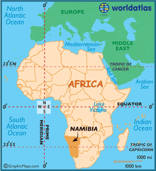
Name: NAMIBIA
President: Hifikepunye Pohamba (2005)
Prime Minister: Hage Geingob (2012)
Total area: 318,694 sq mi (825,418 sq km)
Population (2013 est.): 2,182,852 (growth rate: 0.817%); birth rate: 21.11/1000; infant mortality rate: 45.61/1000; life expectancy: 52.17
Capital and largest city (2009 est.): Windhoek, 342,000.
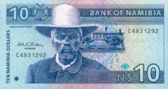
Monetary unit: Namibian dollar
Read more: Namibia:
Maps, History, Geography, Government, Culture, Facts, Guide & Travel/Holidays/Cities
| Infoplease.com http://www.infoplease.com/country/namibia.html#ixzz38bmu9qxa
Description (Page 1)
The nomadic San people were the only inhabitants of Namibia until around 2,000
years ago, then, over the centuries many ethnic groups began to settle the land.
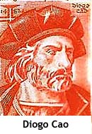 Diogo Cao, from Portugal,
became the first European to
set foot on Namibian soil in 1485, with Bartholomeu Dias the second; however,
due to the inhospitable Namib Desert neither went too far inland.
Diogo Cao, from Portugal,
became the first European to
set foot on Namibian soil in 1485, with Bartholomeu Dias the second; however,
due to the inhospitable Namib Desert neither went too far inland.
Europe's interest
in Namibia peaked amidst the so called "Scramble for Africa"
during the 19th century, and German trader Adolf Luderitz bought a portion of
the region for 10,000 marks and 260 guns.
Relations between the natives and German settlers
deteriorated as the new government encouraged the settlers to take land from the
natives.
In 1904 the rebellion escalated into the Herero and Namaqua Wars. Under the
leadership of chief Samuel Maharero, the Hereros had the upper hand, and had
little problem with defending themselves due to their knowledge of the terrain.
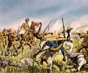 In response, Germanysent
14,000 additional troops to subdue the situation, and at the Battle of Waterberg
the Hereros were issued an ultimatum to leave the country or be killed.
In response, Germanysent
14,000 additional troops to subdue the situation, and at the Battle of Waterberg
the Hereros were issued an ultimatum to leave the country or be killed.
What followed was theHerero
and Namaqua Genocide,
as Hereros escaped into the waterless Omaheke region in the Kalahari Desert
where many died of thirst, and the rest were at the mercy of German forces whose
orders were to shoot any male Herero on sight. An estimated 50-70% of the total
Herero population, and approximately 50% of the Nama population perished.
On October 7, 2007, descendants of Lothar von Trotha, the General who led the German attacks
on the Hereros and Namas, issued an apology for the actions of their ancestors.
Description (Page 2)
South Africa occupied
the German colony
of South-WestAfrica during
World War I and administered it as a mandate until after World War II, when it
annexed the territory.
.png) The
South-West Africa People's Organization (SWAPO) guerrilla group launched a war
of independence in 1966 for the area that was soon named Namibia, but it was not
until 1988 that South
Africa agreed
to end its administration in accordance with a UN peace plan for the entire
region.
The
South-West Africa People's Organization (SWAPO) guerrilla group launched a war
of independence in 1966 for the area that was soon named Namibia, but it was not
until 1988 that South
Africa agreed
to end its administration in accordance with a UN peace plan for the entire
region.
Namibia won its independence in 1990 and has been governed by SWAPO since.
About one-half of the population lives below the international poverty line and
the economy suffers greatly from the effects of HIV/AIDS.
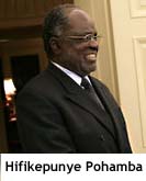 Hifikepunye Pohamba
was elected president in November 2004 in a landslide victory replacing Sam
Nujoma who led the country during its first 14 years of self rule. Pohamba was
re-elected in the 2009 elections by an overwhelming vote.
Hifikepunye Pohamba
was elected president in November 2004 in a landslide victory replacing Sam
Nujoma who led the country during its first 14 years of self rule. Pohamba was
re-elected in the 2009 elections by an overwhelming vote.
Namibia's economy depends primarily on mining – it is the fourth largest
exporter of non-fuel minerals in Africa as
well as the world's fifth largest producer of uranium.
As for tourism, Although Namibia presents a brutally hot climate, travelers
journey here to tour the barren red-sand deserts, and the highest sand dunes in
the world in Namib National Park.
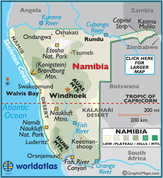
Located south of the Equator,
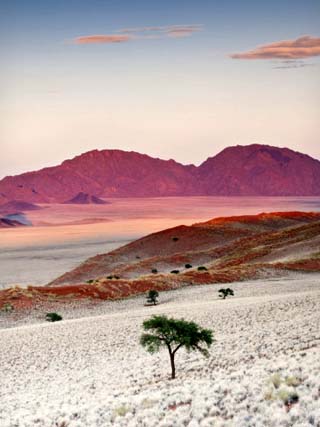
Namibia consists of five geographical areas: the Central Plateau, Namib Desert,
Great Escarpment, Bushveld, and Kalahari Desert.
Running from north to south, the Central Plateau is generally wide and flat, and
contains a majority of the country's population and economic activity.
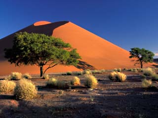
The Namib Desert stretches along the entire coastline of Namibia, and contains
some of the oldest deserts in the world; as well, the sand dunes located here
are the highest in the world.
The Kalahari Desert, however, is Namibia's best known geographical feature, and
is divided between South
Africa and Botswana.
Despite its hyper-arid and sandy nature the Kalahari is home to over 5,000
species of plants.
Rising swiftly to over 6,562 ft. (2,000 m) is the Great Escarpment, whose
landscape is rocky, yet significantly developed. The Bushveld is located in
northeastern Namibia along the Angolan border,
and is a mainly flat and sandy stretch of land.
The most significant river in Namibia is the Fish River, which runs 403 miles
(650 km); its flow is seasonal, and during winter the entire river bed dries up
completely.
The highest point is Brandenburg (Konigstein) at 8,550 ft. (2,606 m); the lowest
is the Atlantic
Ocean (0
m).
Climate:
The climate of Namibia is best described by its summer and winter conditions.
Winter days (May through September) are normally quite warm, but rather cold in
the evenings and early mornings, especially June/July/August.
Summer days (October through April) are significantly hotter, with occasional
heavy rains, January to April.
Because of inadequate rainfall, crops are not widely raised and pastoralism forms the backbone of the agricultural sector. Goats and sheep are raised mainly in the south, and cattle are herded chiefly in the north. About half the people make their living by agriculture, mainly from Karakul pelts, livestock, and dairy goods. Millet, peanuts, sorghum, and grapes are grown. Unemployment is high, and much of the agricultural land remains in the hands of several thousand white farmers; this has led to pressure for land redistribution, and the government has gradually transferred ownership to black Namibians through land purchases, some of which have involved expropriation.
The country's few manufactures are made up mostly of processed food. There is an extensive mining industry, run principally by foreign-owned companies. Namibia is a major producer of gem-quality diamonds, the country's principal export; the most significant diamond deposits are offshore. Other important minerals are uranium, lead, zinc, tin, silver, tungsten, and copper. There are significant but yet unexploited natural gas deposits offshore and iron deposits in NW Namibia. Fishing fleets operate in the Atlantic. Unrestricted fishing by commercial companies severely depleted the country's supply of certain types of fish, but stocks are being replenished.
The central part of the country is served by roads and rail lines that are linked with those of South Africa, its largest trading partner. The main exports are diamonds, copper, gold, zinc, lead, uranium, cattle, fish, and Karakul pelts. Foodstuffs, petroleum products, machinery and equipment, and chemicals are imported.
Namibia is governed under the constitution of 1990. The president, who is head of state, is popularly elected for a five-year term and is eligible for a second term. The government is headed by a prime minister, who is appointed by the president. There is a bicameral legislature. The National Council has 26 seats, with two members chosen from each regional council to serve six-year terms. Members of the 72-seat National Assembly are popularly elected for five-year terms. Administratively, the country is divided into 13 regions.
The country has four main geographical regions: the arid and barren Namib Desert, which runs along the entire Atlantic coast with widths of from 50 to 80 mi (80–130 km); an extensive central plateau that averages c.3,600 ft (1,100 m) in elevation; the western fringes of the Kalahari Desert in the east; and an alluvial plain in the north that includes the Etosha Pan, a large salt marsh. The highest point is Brandberg Mt. (8,402 ft/2,561 m), situated in the western part of the central plateau. In addition to the capital, other towns include Keetmanshoop, Tsumeb, Lüderitz, Gobabis, and Otjiwarongo.
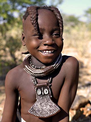
Namibia has an ethnically diverse population that includes the Bantu-speaking Ovambo (about 50% of the population), Kavango, and Herero; various Nama (see Khoikhoi) groups; the Damara; San (Bushmen); and whites of South African, German, and British descent. English is the official language, but most of the population speaks Afrikaans. About 80% of the population is Christian, and the rest follow traditional beliefs.