.jpg)
Tel Code..: +228
Ethopian Airlines -KLM- Royal Air Maroc -Air France
Viza..: Needs
Courses or boosters usually advised: Hepatitis A; Poliomyelitis; Tetanus; Typhoid; Yellow Fever.
Other vaccines to consider: Cholera; Diphtheria; Hepatitis B; Meningococcal Meningitis; Rabies.
Yellow fever vaccination certificate required for travellers over 1 year of age arriving from countries with risk of yellow fever transmission.
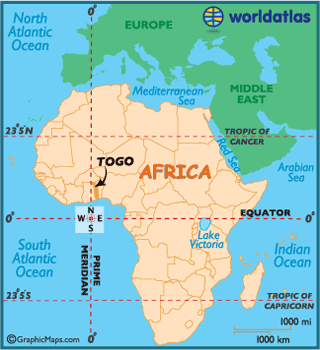
Name: Togo
President: Faure Gnassingbe (2005)
Prime Minister: Kwesi Ahoomey-Zunu (2012)
Land area: 21,000 sq mi (54,390 sq km); total area: 21,925 sq mi (56,785 sq km)
Population (2012 est.): 6,961,049 (growth rate: 2.748%); birth rate: 35.26/1000; infant mortality rate: 49.87/1000; life expectancy: 63.17; density per sq mi: 301.9
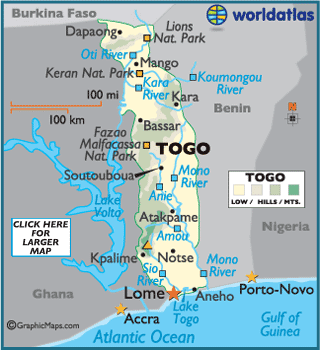
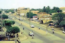
Capital and largest city (2011 est.): Lomé, 1,570,283 (metro. area), 837,437 (city proper)
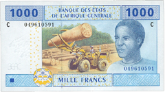
Monetary unit: CFA Franc
Read more: Togo:
Maps, History, Geography, Government, Culture, Facts, Guide & Travel/Holidays/Cities
| Infoplease.com http://www.infoplease.com/country/togo.html#ixzz38ZLflJj7
Officially the Togolese Republic, this country in western Africa has little
written history before the late 15th century.
 Tribes settled along
the coast in the pre-colonial era, and by the 15th century the Portuguesearrived
and built forts in the neighboring countries of Ghana and Benin.
Due to the lack of natural harbours, the region of Togo was overlooked.
Tribes settled along
the coast in the pre-colonial era, and by the 15th century the Portuguesearrived
and built forts in the neighboring countries of Ghana and Benin.
Due to the lack of natural harbours, the region of Togo was overlooked.
In the 16th century the slave trade began in this part of Africa,
and for the next two hundred years this coastal region was a major trading
center for Europeans in
search of slaves.
Subsequently, Togo and the surrounding region was referred to as the "Slave
Coast," and that terrible stigma remains to this day.
In 1905, Toga became the German colony
of Togoland, but after Germany was
defeated during World War I,British and French factions
soon administered this land.
Togo became an autonomous republic within the French Union in 1959, then a year
later, French Togoland achieved independence from France.
 In 1967, following a
successful military coup, Gnassingbe Eyadema was named president, and he
continued his command well into the 21st century.
In 1967, following a
successful military coup, Gnassingbe Eyadema was named president, and he
continued his command well into the 21st century.
At the time of his death in 2005, after serving as president for 38 years,
Eyadema became the longest-serving leader in modern African history.
Shortly thereafter, his son Faure Gnassingbe was elected president.
Gnassingbé's succession was challenged by a popular protest and by threat of
sanctions from regional leaders. Subsequently, Gnassingbé succumbed to pressure
and in April 2005, held elections that legitimized his succession. He has since
been reelected.
Togo's economy is based primarily on commercial and subsistence agriculture,
providing employment for 65% of the work force. Cotton, coffee and cocoa
together generate about 40% of export earnings.
Its former and most prosperous industry, phosphate mining, has virtually
collapsed, due to the fall of the world's phosphate prices, financial problems
and foreign competition.
Most of Cote d'Ivoire (north
to south)
is a forested plateau, one that gradually slopes down to the Atlantic
Ocean coastal
areas.
Exceptions are the edges of the Guinea Highlands (4000
- 5000 ft. peaks)
on its western border with Guinea,
in the far northwest and the elevated savanna and forest of the northeast.
Extending across the middle of the country is the Guinean forest-savanna mosaic,
a transition zone between the coastal forests and interior savannas
The highest point of the Cote d'Ivoire is Monts Nimba at 5,748 ft (1,752 m), and
the lowest point is the Gulf of Guinea (0 m).
Major rivers, including the Bandama, Komoe and Sassandra, drain the plateau.
Large lakes include Loc de Ebire and Loc de Kossou.
Climate:
The coastal regions of Cote d'Ivoire are warm throughout the year, with average
highs near 80°F (26°C). Rainfall here is heavy May through July, with up to 80
inches commonplace,
The forested central region is a bit warmer, with heavy rains March through May
(70 inches on average).
In the northern reaches of the country the daily high temperatures reach into
the 90's (32°C), with somewhat more moderate rainfall amounts.
Agriculture is Togo's chief economic activity, engaged in by about 65% of the workforce. The principal food crops are yams, cassava, corn, beans, rice, millet, and sorghum. The leading cash crops are cotton, coffee, and cocoa. Sheep, goats, hogs, and cattle are raised, and fishing is important. Large-scale mining of phosphate deposits at Akoumapé (in the southeast) began in 1963 and is now Togo's most important industry. Small quantities of chromite, bauxite, limestone, and iron ore are also mined, and marble is quarried. The country's other industries consist mainly of agricultural processing, handicrafts, and the manufacture of basic consumer goods. Attempts to implement economic reforms, begun in the late 20th cent. and including increasing privatization and foreign investment, have met with limited success.
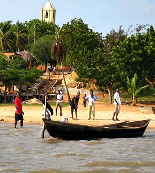
A hydroelectric plant completed in 1988 on the Mono River was a collaborative effort between Togo and Benin. Togo's limited road and rail transportation facilities are concentrated in the central and southern parts of the country; Lomé is the main port. The cost of Togo's imports is usually much higher than its earnings from export sales. The main imports are machinery and equipment, foodstuffs, and petroleum products; the leading exports are cotton, phosphates, coffee, and cocoa. The principal trade partners are Ghana, Burkina Faso, France, and China.
Togo is governed under the constitution of 1992. The president, who is head of state, is popularly elected to a five-year term; there are no term limits. The prime minister, who is head of government, is appointed by the president. The unicameral legislature consists of an 91-seat National Assembly whose members are popularly elected for five-year terms. Administratively, Togo is divided into five regions.
From south to north, Togo is made up of five successive geographic regions. In the extreme south is a narrow sandy coastal strip (c.30 mi/50 km long), which is fringed by lagoons and creeks. A region (c.50 mi/80 km wide) of fertile clay soils lies north of the coast. The third region is made up of the clay-covered Mono Tableland, which reaches an altitude of c.1,500 ft (460 m) and is drained by the Mono River. North of the tableland is a mountainous area comprising the Togo and Atakora mts. and including Mt. Agou (c.3,940 ft/1,200 m), Togo's loftiest point. The fifth region, in the extreme north, is the rolling, sandstone Oti Plateau. The country is almost entirely covered with savanna, which has somewhat thicker vegetation in the south and thinner vegetation in the far north. In addition to the capital, other cities include Sokodé, Kpalimé, Anécho, and Atakpamé.
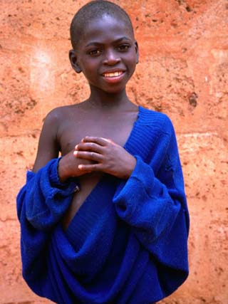
Togo is comprised of more than 35 ethnolinguistic groups, including the Ewe and the Mina in the south and various Voltaic-speaking peoples, the largest of which is the Kabre, in the north. Some 50% of the inhabitants follow traditional African religious beliefs, 30% are Christian (mostly Roman Catholic), and 20% Muslim. French is the country's official language and is used in business; Ewe and Mina are widely spoken in the south and Kabiye and Dagomba in the north.